It was born in 2007 with the idea of observing the landscape and its evolution as a result of the reissue of the book “Botigues de Palma”. It was a work of photographs of commercial establishments in Palma from the early 80s. It was then that “we decided to show the changes that the passage of time prints on these elements of the everyday landscape by adding an updated photograph of them”, explains Jaume Gual Carbonell, one of the coordinators of the Observatori Fotogràfic del Paisatge de les Illes Balears (OFP). “The book was out of print and the exhibition that accompanied it, at the Museum of Mallorca, was very well received by the public.”
Since then, this Photographic Landscape Observatory, framed in the Research Group ‘Audiovisual heritage, mass media and illustration’, of the UIB, has emerged as a witness to the passage of time on the islands. “We realized the importance of the spaces in which they have lived for people. That made us reflect on the opportunity and the need to document, to photograph, our environment in a rigorous and structured way”, Gual explains.
-
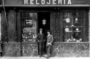
- Relojería Española, en 1911. Foto cortesía de Relojería Española – OFP
-
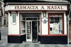
- Relojería Española, ya como Farmacia Nadal, en 1984. Foto de Jaume Gual – OFP
-
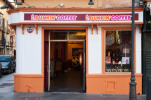
- Farmacia Nadal, transformada en Dunkin Coffee en 2007. Foto OFP
We realized the importance for people of the spaces in which they have lived
Records from the 19th century
To what year does the OFP archive date? Jaume Gual tells us that they have digitized paintings “from the beginning of the 19th century, such as the view of Palma by Bartomeu Sureda Miserol (Museu de Lluc), a lithograph of Port d’Eivissa from 1867 (Die Balearen, Biblioteca March) or a photo of the Port de Ciutadella from 1888. We have a good collection of images of the Fons Bartomeu Reus that covers a period between 1900 and 1940. We have digitized several private collections of postcards (ranging from 1900 to 1970) and that we have also uploaded to the web… To that we must add the current images”.
-
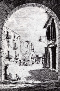
- Plaza de Vila, Eivissa. Imagen Die Balearen, 1867 – OFP
-
- Plaza de Vila de Eivissa, en 2011. Foto, J. Gual – OFP
On the OFP website, which Gual mentions, three types of images or projects stand out: re-photography, comparative photography and documentary collection of the territory, three of the Observatory’s areas of work. “The bottom is fed by the others. It is a mixed bag in which all the landscape images to which we have access can fit. There they are documented and uploaded to the web. Comparative photography is one that we make from an old image and that serves to see changes and permanence in the landscape. Rephotography would be the same as comparative photography, but we use this term to refer to the repetition of the same landscape over time. ”
Comparative photography is one that we make from an old image and that serves to see changes and permanence in the landscape.
-
- Cala_Guix en 1928, por M. Ramírez (Fons d’art del Consell de Mallorca) – OFP
-
- Cala Guix, en 2015. Foto de J. Gual – OFP
Comparing old and current images of the same place offers, over the years, “a stroboscopic vision of the same place, it shows us how changes occur over time in the territory. In reality, re-photographing is to photograph again, make a comparison, but we give it that sense of continuing to photograph from time to time to have that sequence of images that covers a more or less long period. This could be applied to specific projects to monitor the evolution of certain areas that at a given moment we would like to have them monitored”.
Evolution of the landscape on the island
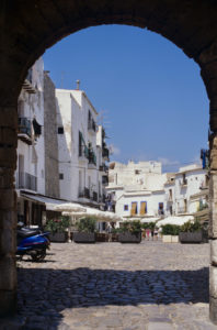
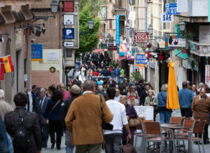
The arrival of mass tourism in Mallorca is one of the milestones that marked the change in the island’s landscape, from the 1950s to the 1960s. “It caused a radical transformation in the landscape in every way,” says Gual, who adds that “the urbanized area increased, numerous centers dedicated to tourist exploitation appeared, new infrastructures were created (ports, airports, highways, industrial estates … .) necessary to ensure the growth of the new economic sector ”.
-
- Carrer Oms en 1985. Foto OFP
-
- Carrer Oms en 2010. Foto J. Gual – OFP
“The landscape is the reflection of the work of a society on a medium, on a territory. 100 years ago the economy was based on agriculture and industry. Today these sectors hardly matter if we compare them with the services sector. This has a direct impact on the landscape ”, says the coordinator of the Landscape Photographic Observatory.
“Extraordinary” transformation of Palma
And within all this transformation, what are the places on the island that have changed the most? “An important part of the coast has radically done it. Also the majority of population centers, although the transformation of Palma, as a center of exchange, merchandise, passengers, etc. it has been extraordinary. In any case, the change has been global since the entire island space, urbanized or not, is subject to the pressure implied by tourist exploitation ”.
-
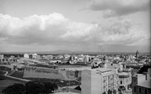
- Plaza de toros desde el Instituto Ramon Llull. Foto de Jaume Escalas, 1930 – OFP
-
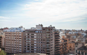
- Via Portugal desde el Instituto Ramon Llull, en 2010. Foto de J. Gual – OFP
According to the coordinator of the Balearic Islands Photographic Observatory of the Landscape, this ‘witness to the passage of time’ only collects graphic information “about what the landscape was like and how it is” and does not go so much into drawing conclusions. “This information can be used by educators, researchers, the media, etc. as the basis for your work. And it will be a reference for politicians when making decisions about the territory ”. What is certain, Gual concludes, “is that the knowledge of the landscape that we had and that we have invites us to reflect on what landscape we want for the future. I think this is our contribution”.
-
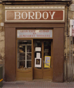
- Bordoy en 1984. Foto de Jaume Gual – OFP
-
- En 2007. Foto de J. Gual – OFP
Leave A Comment