According to the State Meteorological Agency (Aemet), a cold front of polar origin arrived on the island last Tuesday accompanied by a significant drop in temperatures. The change in the weather in Mallorca puts the island on orange alert for gusts of wind that can reach 70 and 80 kilometres per hour.
On Wednesday 22nd November the island is on orange alert for a significant risk of wind in the Serra de Tramuntana and the north and Llevant of Mallorca. The State Meteorological Agency (Aemet) is warning of north wind gusts of up to 70 km per hour with waves of between 4 metres minimum height and 10 metres maximum height.
The orange alert in these parts of the island will remain in force until tomorrow, Thursday. The yellow alert predominates in the rest of Mallorca.
Yesterday, Tuesday, the drop in temperatures was already present with minimum temperatures of 7 degrees in Campos; 8 in Alfàbia and Palma Airport; 9 in Escorca, Manacor, Binissalem, Santa Maria, Palma University; 10 in Llucmajor, Petra, Porreres, Llucmajor, Artà and Sineu; 11 in Lluc, Muro, Santanyí, Sa Pobla, Portocolom and Son Servera; 12 in Calvià, Pollença, Playa de Palma and Andratx; 15 in Capdepera, Port de Pollença and Puerto de Sóller; and 16 in Banyalbufar. These temperatures are expected to be similar over the next few days.
Drop in temperatures: the prelude to winter
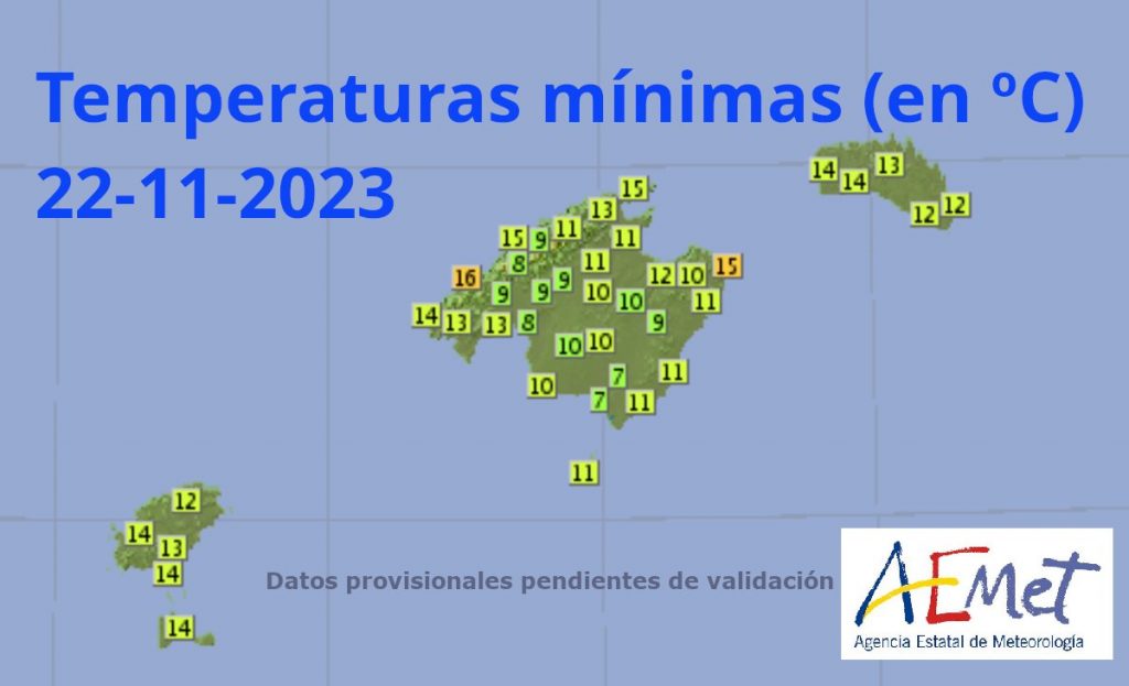
Photo: Aemet.
Temperatures are between 8 and 16 degrees today, Wednesday 22 November. These records are expected to be maintained until the weekend. According to the Aemet, the wind chill will be even lower, due to the strong wind.
The weather forecast for these days also announces cloudy intervals with occasional showers that may be accompanied by thunderstorms and small hail, mainly in the north of Mallorca.
:idea:Here you can consult the weather forecast of the State Meteorological Agency (Aemet) for this week in the Balearic Islands.


Leave A Comment