The Consell de Mallorca has added to the public heritage a genuine jewel of medieval cartography: the illuminated Portolan Chart of the Mediterranean signed by Petrus Roselli (Pere Rossell) in 1447, an exceptional piece from the historic Mallorcan School of Cartography that can be visited between June and November at the Museu de Mallorca.
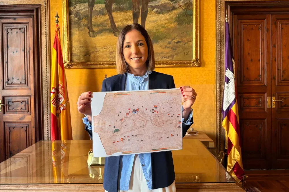
The vice-president of the Island Council and councillor for Culture and Heritage, Antònia Roca. Photo: Consell de Mallorca.
The island institution acquired this work for £762,000 (around €882,000) after learning that it was due to go up for auction in London through the house Sotheby’s. With this operation, the chart becomes part of the public collections of the Museu de Mallorca, where it will be exhibited so that residents and visitors can admire up close one of the most outstanding pieces in the island’s cartographic tradition.
A unique piece from the Mallorcan School of Cartography
The chart, produced in 1447, is the oldest of the ten navigation charts signed by Petrus Roselli, considered one of the most prolific cartographers of the so-called Mallorcan School of Cartography, which flourished between the 13th and 15th centuries and turned Mallorca into one of Europe’s great centres of cartographic production.
It is an illuminated portolan chart of the Mediterranean world, made on a single large vellum membrane (56 × 94 centimetres). The map is drawn in brown ink and contains hundreds of place names written in black and red in a meticulous Gothic script, combining nautical precision with remarkable artistic value.
Portolan charts were essential tools for medieval navigation. Thanks to their network of rhumb lines and the precision of their coastlines, they allowed sailors to navigate the Mediterranean with far greater accuracy than other maps of the period.
“Protecting, recovering and making our historical heritage accessible to the public”
During the ordinary plenary session of the Consell de Mallorca, the institution’s vice-president and councillor for Culture and Heritage, Antònia Roca, explained the acquisition of this historic piece and stressed that “this exhibition will allow the people of Mallorca to see the Portolan Chart of Pere Rossell up close and place it within the great tradition of the Mallorcan School of Cartography. At the Consell de Mallorca, we continue working to protect, recover and make our historical heritage accessible to the public.”
Leave A Comment